An amazing hike, one of my favorites that will give you great views for not too much of a climb. I started this hike up

White trail markers to follow
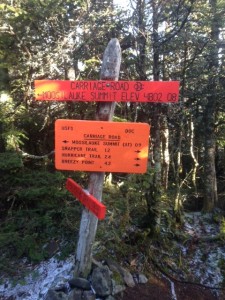
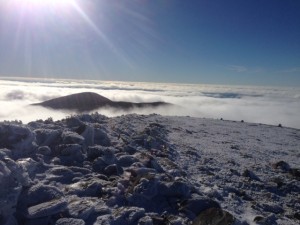
the glencliff trail. It starts off real pretty and easy taking you through a couple of fields where you can look up and see the mountains you’re about to climb hovering over you. In the first .4 miles the trail enters the forest and then splits, stay left on the glenncliff trail. following the white trail markers for 2.6 miles (which has really only one steep section the whole way) until you reach the South Peak junction. Here you will come to orange trail signs, make sure you follow the one that says “Southpeak .2 miles”. Once y ou take this trail you will have spectacular 360 degree views at the peak and will be able to see the ridge that goes right up to Mt. Moosilauke. This first peak is an ideal spot for a break or just taking in the sights. Then go back down to the junction and follow the orange sign (pictured right) that says Moosilauke summit .9 miles. The ridge over to Moosilauke is so nice and flat and you may have the urge to run it! Once you start ascending again get your cameras ready because you will be entering the alpine zone (above tree line). After the total 3.9 mile hike (4.1 with south peak) out you have reached the top of Moosilauke and boy are the views something else! On the day I went we were above the clouds and spent as much time as we could up there. So much that we couldn’t do the loop we wanted to so we went back down the way we came. Once you’ve finished your roughly 8 miles (6.5 hours) of hiking for the day you will be back on the old logging road you started on and then back to the parking lot, where hopefully your car still is!
FYI
- This hike does not have a whole lot to it. The biggest thing is be prepared! Weather can turn quickly up in the mountains and especially in the alpine zone.
- If the weather turns and you are not prepared for it do not go into the alpine zone because the conditions will only get more extreme here.
- Make sure you have enough food and water for the 8 mile hike (always better to be over prepared)
- Follow the signs and you’ll be good!
Getting There
Getting to the trailhead in Glencliff, NH is pretty straight forward, however the first turn off of Rt. 25 onto High St. can be easily missed. Starting your way to the trailhead take exit 26 off of I-93 onto Rt. 25 West, stay on this route taking the first exit on the rotary you come to. After the rotary you stay on 25 West (merges with 118 for a bit) for 20

Parking lot sign for trailhead
miles until you see High st (Glencliff,NH) on your right. Stay on High St. for about 1.2 miles until you see the parking lot on your right. FYI if you cross the town line past Glencliff you have gone too far and missed the High st. tu rn. Also the parking lot is right across from a healthcare facility sign (pictured right)
